
Phase II has come to an end. It was a great season and an especially interesting experience with both summer and winter operations. The new crew arrived right on schedule on October 8th via two Twin Otters from Akureyri, Iceland. The following week was a whirlwind of turnover with the new crew: training them on equipment and procedures, reviewing protocols and paperwork, getting them accustomed to the 10,550ft elevation and -30F temperatures and helping them get settled in with all the various idiosyncrasies that make up Summit Station.
On October 16th we officially handed over the reins. Two Twin Otters were scheduled to land just after noon, but the day had dawned with 20-25 knot winds and a fair bit of blowing snow in the air. Visibility was below their minimums with a worsening forecast. Still, the weather in Akureyri, Iceland and in East Greenland was clear and beautiful and they were going to try. As the day progressed we continued to submit hourly weather reports – the Phase III manager doing the observations. I stood by to answer any questions and assist with preparations for the flight. They had off-decked that morning on time, so while we were mentally prepared for them to cancel we also had to be ready to go. As their ETA drew closer the visibility stayed between 300-400 meters. The SOB was barely visible from the Big House.
The first Twin Otter called on the Air to Ground radio when they were about 15 minutes out asking for a current weather observation and confirming that they would attempt a landing. They could see the skiway markers, it was a localized storm, only a couple hundred meters high, and the wind was coming straight down the skiway. The mechanics pulled the loader and fuel tanks out to the taxiway, turning all their lights on to increase visibility, and the science techs readied their snowmobiles to transport freshies to the Big House and pax bags to the plane. We held our breaths and strained to see the plane in the whiteout as they reported over the radio that they had landed safely…”Norlandair 4 is on deck…but, we’re having a hard time seeing the flags, would it be possible to get a snowmobile escort to the fuel pits?” We escorted them in, began fueling, and unloaded the fresh food for Phase III. The pilots were unfazed and friendly. The second plane landed a few moments later without issue.

The first plane fueling with blue sky above

Norlandair!
When we deployed in June 2015 we flew commercially to Scotia, NY where we boarded Air National Guard LC-130 Hercules planes and flew north to Kangerlussuaq, Greenland via Goose Bay, Canada. After a few days in Kanger we continued onwards up to Summit still on the Hercs. Redeploying now in October the LC-130s have flown South leaving Greenland for a period of maintenance before beginning the main summer season in Antarctica. Travelling to and from Summit then is done via Twin Otter – flying East with a quick stop in Constable Pynt on the rugged and isolated coast to refuel and Southward to Akureyri, Iceland.
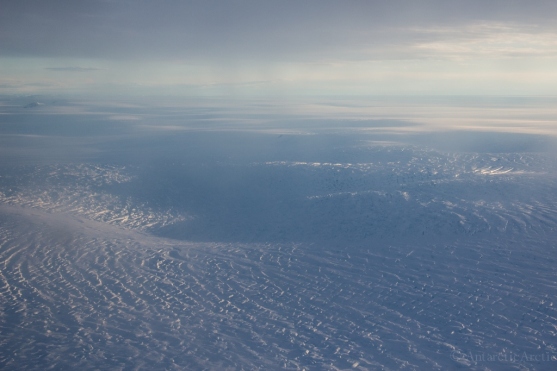
I’ve never been East of Summit in Greenland and at first it’s the same flat white. The storm is indeed localized, not 15 minutes away the clouds clear and the sastrugi glitters in the sunlight as we cruise above.

Fair weather just away from Summit
But then darkness appears on the horizon: mountains. Undulations form on the surface and a slope becomes apparent. I can see the ice flowing together and pulling apart, forming a more defined glacier – crevasses gape, indicating an increase in velo city. There’s no scale to show how huge they are. A nunatak appears, the tip of a mountain peaking above the ice. Then more – the ice lowering gradually, revealing mountains. Soon the ice is flowing between rock. Sheer granite walls rise above massive, epic, classic glaciers. Jagged peaks reach to the sky, dribbling rocks down their flanks to the ice below. Perhaps it is simply because I’ve seen only the flat white since May, but it is stunning and I can’t contain my excitement as I move from window to window. The sun is starting to set and the light is beautiful. It’s an inhospitable land: impossible to traverse. Perhaps some lichen or moss exists here, maybe the occasional bird, but there can’t be much else. Precipitous cliffs press against crevasse riddled ice as far as the eye can see. Further on, liquid water appears and the ends of the glaciers crumble into the dark reaches of the fjord. Icebergs! The sun sinks lower, behind the mountains, bathing the landscape in gold and pastel pinks and blues and we begin our abrupt descent to Constable Pynt. Not much more than a landing strip scraped clear of snow and some fuel tanks, it’s a quick stop and then we’re off over the far North Atlantic, heading south now to Iceland.

Inside the Twin Otter – the pilots up front, then the ferry fuel tank (extra fuel for the long flight) and us in the back.


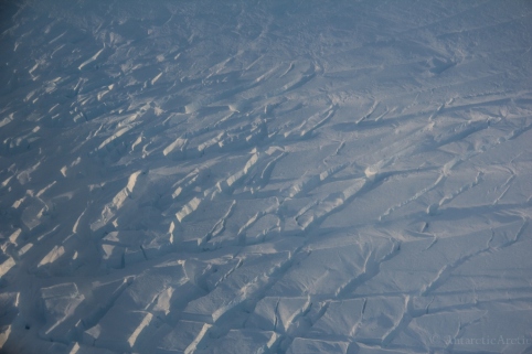
Crevasses


Constable Pynt, East Greenland

Refueling in Constable Pynt

Arctic foxes (one white one brown) at Constable Pynt

It’s dark when we land in Akureyri. The town lights gleam and the air is laden with the smell of fall; the sweetness of decaying leaves, the hint of fresh grass and life, the salt from the sea. It’s windy and we couldn’t be happier. The next morning we fly on to Reykjavik and after a long layover, back to the U.S.

The cathedral in Reykjavik, Iceland Oct 17
It was a record fast turnaround for me this year. Less than 48 hours to unpack and repack, take a bath, enjoy some crisp fruits and veggies, then back to the airport. Greenland to Antarctica in less than a week!
This year I’ll be working as an equipment operator on a small traverse shuttling materials from Byrd camp to WAIS Divide. There are no plans for a camp in the near future at Byrd, so much like last season (Pig Diggers, WAS Recovery) it will be a skeleton crew working to return material back to McMurdo where it can be used for other projects. WAIS Divide is a fairly significant camp as far as deep field camps go – a staff of 15 will support a number of science groups operating out of there. Byrd however, will have a crew of just 4; their primary task being to excavate the cargo stored out there and either return it to WAIS Divide via our traverse or fly it back to McMurdo via LC-130 Herc. As far as traverses go ours will be pretty minimal with just two of us driving Tucker Sno-cats over the 100-mile stretch between the two field camps. In the field, far from the main stations, we will have no internet access though we will be carrying satellite phones and a portable HF radio.
Byrd has a long and varied history – from a year-round station to a summer only field camp. The Antarctic Sun did a nice piece on the history of Byrd history: Antarcticsun.usap.gov
I also reviewed some of it’s history back in 2012-13 when I was working as the equipment operator out there for the summer: antarcticarctic.wordpress.com/byrd-surface-camp-2012-13
So thanks for following along this summer! And stay tuned for the next grand adventure…The West Antarctic Support Traverse 2015-16!

Kiwi graffiti in Christchurch, New Zealand Oct 22

Welcome to Antarctica! Getting off the C-17 in McMurdo, Antarctica on Oct 23
