Arctic Cruise: Baffin Island and West Greenland Part II

20180808-IMG_6802sm

We crossed the Davis Strait at night and woke the next morning to the dusky mountains of Disko Island emerging from the fog. Absolutely massive ice bergs sat serenely in the ocean water, deceptively static. Our first stop in Greenland was Qeqertarsuaq, a classic Greenlandic town with brightly painted houses clustered around winding roads and a sheltered harbor for the fishing fleet. Dog sleds sat idly in yards green with summer grass. The dogs themselves were chained up in their area of town – these are working dogs, not pets.

20180808-IMG_9276sm

Next on our itinerary was the town of Ilulissat, Greenland’s tourist hub and home of the famous Jakobshavn Glacier, the largest of all Greenland’s glaciers, and the unique ice fjord – a World Heritage Site. It was a slate grey day with a heavy drizzle falling. Rain or no the ice fjord was not to be missed! We hiked up along the short boardwalk to the overlook arriving just in time to see humpback whales playing amongst the ice bergs. The Jakobshavn Glacier itself, like most of the world’s glaciers, is retreating at a startling rate (covered in a great article by the Washington Post in 2017). However, due to a shallow moraine just beneath the water at the fjords mouth the giant ice bergs that have calved from the glacier are prevented from floating out to see. Every now and then one will slip over and eventually they melt enough to sail across, but for the most part the entrance to the fjord is choked with ice. It is a remarkable sight and so thick with ice it’s easy to forget that it’s not actually the glacier.

20180809-IMG_9453sm

Cold and damp, we walked back into town. Only inside a Greenlandic café is it normal to 20180809-IMG_6817smsee a huge piece of humpback whale baleen and seal fur cushions. These animals are hunted for their meat and fur and to preserve their disappearing cultural traditions. Whaling is a significant part of Greenlandic culture and has played a major role in their history. While it’s still legal today, it is far from a free-for-all; the whaling permits and licensing is tightly controlled and can be found here: https://iwc.int/catches. Seal populations are much more stable and it is common to see seal meat in markets and grocery stores. The fur is usually saved and treated for use in clothing.

20180809-IMG_9404sm

The Ilulissat Harbor

From Ilulissat we sailed out of Disko Bay, weaving around giant ice bergs, and south to Sisimiut. In the summer of 2017 I hiked from Kangerlussuaq to Sisimiut (on the Arctic Circle Trail) and it was nice to visit the town again. Sisimiut is a bustling town with a high school, a hospital, and large harbor. It is a rare community with an open harbor year-round, but still with enough ice to run dog sleds in the winter. We had an afternoon to visit the museum and walk around town. The sun broke through this day as well and we had a celebratory dinner on the back deck.

20180810-IMG_6878sm

The Akademik Sergey Vavilov in Sisimiut

That evening we sailed down to the mouth of the Kangerlussuaq fjord. At 120 miles long it is the longest fjord of Western Greenland. All night was spent working our way inland to Kangerlussuaq. The first part of the fjord is lined with remarkable and dramatic walls with glaciers peaking from behind. Further inland, the terrain has been smoothed by the ice cap and the awe inspiring cliffs give way to gently rolling rounded hills.

20180811-IMG_9952sm

Kangerlussuaq, our last stop of the trip, is notable for it’s proximity to the Greenland ice sheet. I have spent a fair bit of time in this town as it has the largest airport and is the primary logistics hub for science support in Greenland. Perhaps the most exciting activity in Kanger is visiting the ice edge – where you can walk onto the ice cap itself! It is a relatively short ride via truck or bus to the most accessible point of the ice know as Point 660. I have written about this here. On the way to the ice edge we saw musk oxen, caribou, and even an arctic hare!

Stepping onto the ice is a little surreal. The edge itself is hard to locate exactly as it blurs into the bordering muddy moraine – mud and gravel slowly slowly becoming frozen mud and frozen gravel and then gradually becoming more ice than rock. The scale is hard to describe and the significance of this place was not lost on our group – the ice we stood on is part of the Greenland ice sheet covering more than 656,000 square miles, or 3 times the size of Texas.

The ice on the surface of a glacier has a rough texture. This is because after the snow fell it was buried  by more snow and ultimately compressed to form essentially an unbroken block of ice the size of the glacier’s base. This can be seen in ice caves where looking into the walls can look almost like looking into water. As this ice nears the glacial terminus, and the layers above it melt, the great pressure is gradually released and fractures form along the ice crystal planes, resulting in roughly ice cube sized chunks. This fracturing also brings light into the surface making it appear white (like when you chip an ice cube and the cracks are white).

20180811-IMG_6902sm

At last our trip had come to an end and we returned to Ottawa by plane.

20180812-IMG_6954sm

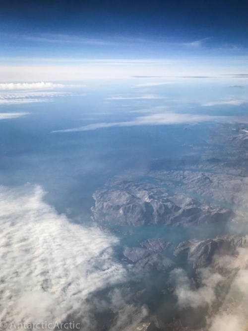
The view from the plane looking down over the West Greenland coast

Baffin Island and West Greenland

Our Group on the Arctic Cruise – photo by One Ocean photographer Dave Sandford

1 Comment

Filed under Arctic, Greenland, Kangerlussuaq

Arctic Cruise: Baffin Island and West Greenland Part I

Part I
Less than six months after leaving Summit Station Greenland, thinking I might never return to the Arctic, I found myself headed North once again. Never say never!

A few weeks prior I had received a call asking if I would be available to fill in as the trip leader on a 12-day alumni trip with my alma mater: a cruise to Baffin Island and West Greenland. I would be expected to give several lectures on my experience in the Arctic and be the point person for our group. Due to the size of the ship this would be a combined trip with alumni from three other colleges as well. I jumped at the opportunity.

20180802-IMG_6704sm

After meeting as a group in the Canadian capital city, Ottawa, we continued via small plane to Iqaluit, Canada. Iqaluit sits near the head of Frobisher Bay and is the capital of the Nunavut Territory. At 63°44′55″ North and 68°31′11″ West it is south of the Arctic Circle, but the soil is so bare there are almost no trees. The landscape surrounding the town is comprised of glacially scoured hills dotted with lakes and ponds. That first day we got a tour of the town and had some time to explore on foot. The population of Iqaluit is roughly 8,000 and it’s economy is based on fishing, tourism, and the airport. Art is valued in communities all around the Arctic, and Iqaluit is no exception. Statues and sculptures can be found scattered around town and large colorful murals cover otherwise bare walls.

20180802-IMG_8754sm

A giant polar bear mural

20180802-IMG_8780sm

St Jude’s cathedral in Iqaluit

There are three official languages of Nunavut: English, French, and Inuktitut. While the spoken language is somewhat related to other Arctic Inuit languages the written Inuktitut language is based on the Cree syllabary in contrast to Greenlandic and the Alaska Inuit languages which are based on Latin.

Later that afternoon we were brought via bus to a beach where we were met by a handful of zodiac skiffs and crew. We boarded in groups and off we went!
The ship was the Akademik Sergey Vavilov – a retired Russian research vessel now used primarily as a cruise ship in the Arctic and Antarctic with oceanographic researchers on board during their transits between the two poles. Our luggage was already onboard and we were met with a welcome and safety briefing before settling into our cabins.
The next few days were spent sailing along the South Eastern shore of Baffin Island. Sea ice, high seas, and heavy winds prevented the first planned shore excursions, but we sighted several Bowhead whales, many sea birds, and some dramatic views of the rugged shoreline through the clouds.

20180809-IMG_9385sm

Disembarking the zodiac

20180805-IMG_6760sm

The Akademik Sergy Vavilov

Our first stop was a small village called Pangnirtung, Nunavut located just north of Frobisher Bay. Here we were given time to explore on foot and treated to several demonstrations at the local community center of traditional throat singing, some of the Arctic Winter Game events, and the lighting of a qulliq lamp by one of the elders. In town we toured craft shops displaying beautiful carved statues and jewelry as well as a collective weaving workspace and a renowned printmaking shop.
At the head of the bay is Auyuittuq National Park, a dramatic glacially carved landscape with tall peaks, sheer walls, and winding fjords.

20180804-IMG_8976sm

Pangnirtung nestled beneath the fjords walls

20180804-IMG_9021sm

Auyuittuq National Park in the distance

Our final shore excursion on Baffin Island was at Cape Mercy. Once a Cold War Distant Early Warning (DEW) line site, the now automated radar station still stands forlorn atop the hill. It was a grey day with a biting wind blowing, yet beautiful and raw. We spent several hours hiking around the beach and hills. One of the most exciting sights was the discovery of polar bear remains. The presence of the claws and skull indicated a natural death (these are the trophy items poachers rarely leave behind) and the dead grass around the bones suggested the skin had rotted away in place. The bones had been scattered likely by scavengers such as fox and eagle. On the zodiac ride back to the ship we cruised around impressive ice formations admiring their surreal shapes and brilliant light.

20180805-IMG_9156sm

It was a quick visit and soon we returned to the ship and headed back into the Davis Strait. The hope was to sail North to find more solid sea ice, where we might also find polar bears, before turning East towards Greenland. During this time at sea, and throughout the trip, each of us leaders presented lectures on a variety of subjects: Current events and political issues, Marine mammal adaptation to warming ocean temperatures, Arctic Climate Change in general, the History of Arctic Exploration, Ice and Marine Ecosystems, Arctic Science Support and Winters on the Greenland ice sheet.

It was during this segment that we crossed the official Arctic Circle: 66°33’ North. Unlike the arbitrary lines of longitude, the Arctic Circle, like the equator, marks a physical aspect of our planet. Above this line the sun never sets on the winter solstice. Many of the guests on board had never crossed into the Arctic and were very excited. A small celebration was held with toasts and photographs.
After a day and night spent chugging through thick fog and rolling seas we finally reached the sea ice edge. All eyes were glued to the horizon as we scanned the sea ice and fog for polar bears…there were a couple of false alarms, until we indeed spotted one! It turned out to be a mother, with two cubs. She moved slowly, navigating through the rough and broken sea ice, her cubs in tow. We edged as close as we dared, given the ice and waves, and there they were: unmistakable through binoculars and zoom lenses! Our polar bear sighting achieved we departed Canada and sailed East for Greenland.

20180807-IMG_9216sm

Fog, sea ice, and waves

20180807-IMG_9247sm

First Polar Bear Sighting

20180807-IMG_9253sm

The professional photographer

20180807-IMG_9245sm

A mother bear and two cubs

2 Comments

Filed under Arctic, Canada

Farewell to Summit Station

I left the ice in early February and hit the ground running with a lot of things happening over the past few months. So, better late than never?


20180209-IMG_6903-sm

There’s a saying in the polar programs:

“I hate this place! I love this place! I’m never coming back. See you next year!”

Someone even made t-shirts one season in McMurdo with that printed on the back. I’m not a fan of this because while there are a lot of people who say this, more or less, their bitterness can ruin the experience for others. But it does exemplify the complicated relationship we all have with the ice. After a season or two most everyone has something they can’t stand. People get burnt out, toasty. After a point we say someone is “perma-toast” – when they come back and are just as toasty as when they left last season. And that’s when they shouldn’t come back – for their sake and everyone who has to work with them.

SO…I have been careful not to say: “I’m never coming back.” But I knew this would be my last season at Summit, at least for a while. So I tried to notice and appreciate all the parts that I love most. I froze bubbles and threw hot water into the air (Hot and Cold Science). I witnessed the beautiful and entrancing reflections of LiDAR on falling ice crystals (Rave Ice). I stood out in -75F temps and listened to the whooshing of my breath freezing as it blew past my ears. I took hundreds of aurora photos and just stood outside under the dark Arctic sky and looked at the stars. I learned constellations and thought about the ice and the darkness. Yet, despite all I love about the ice I am also burnt out, I am ready for a change, for the next chapter.

20180209-IMG_6839-sm.jpg

My flight from Summit arrived on February 9, just a day late due to foul weather in the Denmark Strait between Iceland and Greenland. We were eager for the plane to arrive – to welcome our incoming replacements and receive resupply. The mechanic waited in the shop going over the equipment to refuel the plane and checking the machines to tow the fuel sled. The science techs worked quickly to complete their daily rounds and duties before the folks arrived. I had woken early to start supplying hourly weather observations and cleaned the Big House, waiting by the radio, email, and satellite phones for word of their progress. First we got news that they had departed Iceland, then that they had landed at Constable Pynt (their mid-way refueling point). I announced this over our local radios and everyone wrapped up their projects and prepared for the plane’s arrival.
About an hour before their estimated arrival time the air-to-ground radio in the office erupted with static. I grabbed the mic: “Norlandair, Norlandair. This is Summit on 123.45. I hear you 5 by 1. Do you copy?” Crackling static…but with the hint of a voice beyond. A few minutes later I called again. And this time I could hear their reply! As they approached the signal grew stronger. They requested a weather observations and asked a few questions about the skiway conditions. I relayed to the crew on site that they were about 25 minutes out and wrote a few last minute notes on the white board for my replacement.

The sleek Twin Otter landed smoothly on the snow. They taxied to the fuel tank and the pilots climbed out, opening the door for the passengers in the back and greeting the mechanic with his re-fueling hose at the ready. I waited by the radio until Phil, the incoming manager, arrived and we hugged – then I gave a quick briefing and pointed out my copious notes around the office, grabbed my bags, and made my way out to the plane. The Icelandic pilots were cheerful and grinned at us behind their bundled cold weather clothes. The Twin Otter gleamed in the low angled sunlight. It’s bright red paint in stark contrast to the deep blue sky and sparkling snow. We had just 5 hours of daylight and the forecast was questionable so I climbed on board and we were off, flying over the station and to the East. I sat, overwhelmed with mixed emotions, looking out the windows at the scattered buildings, worn foot paths, and flag lines stretching across the snow…and then it all receded, and was soon lost in the expanse of ice of the polar plateau.

20180209-IMG_6655-sm

The auxiliary fuel tank inside the cabin


20180209-IMG_6643-sm

Farewell Summit Station


The flight over East Greenland was as beautiful as ever. After a few hours of flying over flat white the ice began to buckle and ripple beneath us. Tips of mountains, called nunataks, poked through the ice; the dark rock standing in sharp contrast to the white snow. The ice thinned, giving way to proper mountains. Sheer vertical cliffs rose up, dividing the ice into deep valleys that shunted it to the sea. Beautiful granite and impressive icefalls covered some of the most rugged terrain I’ve ever seen. Eventually the ice in the valleys met flat sea ice, which in turn broke around the edges into open water.


20180209-IMG_6717-sm

20180209-IMG_6761-sm

20180209-IMG_6815-sm

20180209-IMG_6820-sm

We stopped in Constable Pynt for a quick re-fuel. I was able to get out and stretch my legs 20180209-IMG_6872-sm
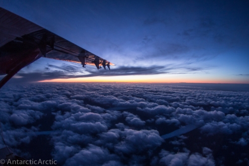
a bit, even sighting an arctic fox on the hill! Inside the little waiting room a poster on the wall advertised the closest town on the Eastern Greenland coast: Ittoqqortoormiit. And then we continued on past the Eastern edge of Greenland to the ocean. The sun settled behind the mountains and ice…leaving us to land in the dark in Akureyri Iceland.

20180209-IMG_6888-sm

20180209-IMG_6912-sm

Due to a snow storm everything in Iceland was shut down for the following few days and I enjoyed soaking in hot pools, meeting with some friends in town, and resting up after a long season.

While I am not planning to return to Summit I am sure that I will return to high latitudes sooner than later. I will write more then 🙂

20180211-IMG_7001-sm

Downtown Akureyri

20180211-IMG_6979-sm

An Icelandic sculpture

2 Comments

Filed under Arctic, Flights, Greenland, Summit Station, Winter

Sunlight

After 2 and a half months of darkness the sun has returned to Summit Station. Over the past few weeks we have watched as the mid-day skies grew lighter each day. Any light, however diffuse, is welcome and we have had some beautiful dawn and dusk colors.
Sunrise was officially on January 28, 2018, however due to poor weather and low visibility it was obscured almost the entire week, until Saturday…

Looking out the window I could see the clouds were breaking up, and around 10am I saw the sun’s orb partly shielded by haze. Molten gold, it lit up the clouds and soon stretched its rays to the surface. As I did my station rounds I saw my shadow for the first time since November. I stared in awe as the buildings were bathed in brilliant light, windows and exhaust vents glinting, and the blue surface of the snow turned a pale gold. I blinked away the ice on my lashes and stared into the sun until it was burned into my eyes. Just feeling the light on my face was more than enough. I love the night sky and the darkness, but it must be balanced with the light.

IMG_6622_HDR

HDR image of the sunset behind TAWO, the 10m met tower, and the GISP2 borehole

Despite the sun’s return it’s still very cold: -60F today with a windchill of -90F and the sun is above the horizon for just 4 hours. Not quite out of winter. We were also hoping to see the full lunar eclipse on Jan 31, but unfortunately just as it was becoming visible the moon slipped behind a layer of hazy clouds.

20180131-IMG_6482

Start of the lunar eclipse on Jan 31

Back in 2015 however, I was here for another lunar eclipse that did not fail to amaze:

Lunar Eclipse

2 Comments

Filed under Arctic, Greenland, Summit Station, Winter

Hot and Cold Science

There’s an old saying that to make ice cubes freeze faster use boiling water in the tray rather than cold water as one might guess. Perhaps surprisingly, there might be some scientific truth to that…it’s called the Mpemba Effect.
The exact science behind this phenomenon is still being worked out and debated, however it raises some interesting questions. Last year Nature published a paper arguing that the Mpemba Effect doesn’t actually exist while another paper published earlier this year in the Journal of Modern Physics suggested that it does indeed exist, perhaps having to do with the structure of water collapsing when heated leading to more random collisions between molecules and thus faster cooling.

{If you’ve heard the old adage about the reverse phenomenon, that cold water will boil faster than hot water and are wondering if that’s true now, I’m sorry…that one has been proven false. Cold water does however bypass the hot water tank in your home and may taste better even if it takes longer to boil.}

But going back to the process of hot water freezing…
Another interesting phenomenon occurs when very hot water meets very cold air. Hot water contains more energy and has less structure (as explained by the above article in the Journal of Modern Physics). It’s actually closer to steam than cold water. So when it’s thrown into the air it breaks apart into tiny droplets each with a large surface area, facilitating the evaporation and freezing processes. Hot water thrown into cold air freezes almost instantly creating an impressive cloud of ice particles and fog. Try again with cold water and you’ll just end up with a puddle of ice on the ground.
Huffington Post published an article back in 2014 explaining this effect with some cool videos (www.huffingtonpost.com/boiling-water-extreme-cold-water-gun-ice). With the recent cold weather across the US I imagine there are lots of posts about this too.

This works best at temperatures below -40F and makes for some pretty cool photos. Unfortunately, we don’t have the bandwidth to upload videos here, so these pictures will have to do.

-90F at the South Pole on March 25, 2013:

-50F at Summit Station on December 5, 2017:


20171205-IMG_4850

-55F at Summit Station on December 1, 2016:

Summit_16-17_Flickr-146


IMG_53420171229-7
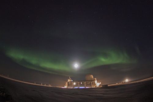
We also experimented with freezing bubbles. However, with no trees or mountains to break the wind it’s generally too windy for bubbles to last very long. It’s also been pretty cold lately at -75F last week so they freeze very quickly, often bursting.


20171103-IMG_4938

If you’re looking for more fun science projects to do at home this winter check out this awesome post by NPR: www.npr.org/dont-just-shiver-here-are-3-cold-weather-experiments-to-try

And if you’re still interested in the science and history of cold check out the aptly titled, fascinating, and well written book: Cold by Bill Streever.

2 Comments

Filed under Arctic, Greenland, Science, Science!, Summit Station, Winter

Happy New Year!

20180101-IMG_6341

An overexposed full moon with a nice halo and some faint aurora over the MSF on Jan 1, 2018

20171225-IMG_5133

The full moon over the Big House  framed by aurora

20171229-StarStaX

Star Trails around Polaris: the bright line of light in the lower left is a science tech’s headlamp off to launch a balloon, the dashed line in the middle is a tumbling satellite, and two iridium flares can be seen in the lower right.


1 Comment

Filed under Summit Station, Winter

Dark Days

20171219-IMG_5091.jpg

1 Comment

Filed under Summit Station, Winter

Happy Solstice!

Summit_Happy_Solstice_2017
It’s December 21, the date on which the North pole is farthest from the sun. Mid-Winter for those in the North…and Mid-Summer for those down South. Here at Summit it’s the darkest day of the year, without even civil twilight.

Summit is at 72deg North which is further north than Barrow, AK and Tromsø, Norway, but not quite as far North as Svalbard. Unlike at the South Pole Station where there is no difference between “noon” and “midnight,” on the darkest day here we will see a bit of light on the horizon to the south. It’s kind of nice to be able to walk around without a headlamp, but it’s fleeting. It lasts just for a few hours and then it’s dark again.
MidWinter Solar Graph.jpg
The solstice marks the halfway point of winter. It will begin to get just a little lighter each day until the summer solstice on June 21st. While the darkness doesn’t bother me too much we haven’t had many auroras this year and I am looking forward to seeing the sun again. Mid-winter is a big deal for Antarctic stations, especially at the South Pole (here’s a link to my mid-winter post from 2013: /”>antarcticarctic.wordpress.com/happy-mid-winter and an article by the Antarctic Sun on mid-winter celebrations:antarcticsun.usap.gov). The June solstice is celebrated with a fancy dinner and solstice greetings are sent between stations, but the December solstice is in the midst of the busy summer season down south and celebrations are typically combined with the holidays. Summit is somewhat of an anomaly all alone in the North, but as an official polar research station and the largest U.S. Arctic Research Station we join in the exchange of greetings with the stations across Antarctica.

IMG_5306

So, Happy Solstice and Happy Holidays from the Summit winter crew!

1 Comment

Filed under Summit Station

Rave Ice

Last winter I was in the midst of my monthly building checks when I went out to visit the Mobile Science Facility (MSF). It was a dark day and snowing lightly. I noticed a flickering light on the snow out of the corner of my eye and proceeded to the back of the building where there are no outside lights. In the shadow of the building and under the angled LiDAR beam the ground was alive with bright green flashes of light.

The LiDAR laser is mounted to the roof of the Mobile Science Facility (MSF) and is part of the ICECAPS project which is looking at atmosphere, precipitation, radiation, and cloud properties over the Greenland ice sheet.
The science techs had noticed these reflected lights earlier, but I had not seen it before. It was truly magical! The lights danced and flickered around lasting only a fraction of a second. Some streaked across in lines, others just flashed a tiny spot, still others revealed intricate interference patterns on the snow. Later that evening the techs and I returned with our cameras. Like auroras, it’s difficult to capture the movement, but still beautiful and interesting none the less!

summit_16-17_flickr-155

It was reminiscent of disco ball lights, but faster and brighter. At first we called it “Disco Ice,” but that wasn’t quite right…lasers, neon green, a high frequency pulse… “Rave Ice” was a better fit.

Intrigued, we decided to do some research to find out what exactly was happening. Was this a normal LiDAR by-product? How was it related to the falling or blowing snow? What did it tell us about current atmospheric conditions? Surprisingly we found almost nothing on the topic. One paper described a similar phenomenon, however the authors said it had only ever been observed in controlled optics research labs and computer programs, never outside. They speculated that snow or ice crystal size, shape, and orientation could be inferred from the light patterns displayed. One of the science techs wanted more information and reached out to the authors sharing some photos we had taken. They were amazed.
This phenomenon has most certainly been occurring since the LiDAR was first installed in 2010. However, it is rare, can only be seen in the dark, and had never been documented until last winter (2016-17). Over the next few months the ICECAPS Primary Investigators, the science tech here, and the optical researchers collaborated to write an article explaining the unique phenomenon. It was published in the July 2017 edition of Applied Optics!

They were able to link the patterns we photographed, the ice crystals we collected, and the shapes and patterns they had modeled in their labs. For example, a bullseye pattern is created by a smooth sided disc, while a bright spot surrounded by six broken dashed lines is a distinct hexagonal plate. We saw both of these patterns and also collected these types of crystals during the event.

It appears that this phenomenon occurs relatively often. When seen from afar the LiDAR beam glints and sparkles reflecting off the crystals. But conditions must be just right to get well defined patterns. There can’t be too much freezing fog, it can’t be blowing tons of snow, it needs to be dark, and there needs to be some precipitation. While any crystals will reflect the laser the most intricate patterns are a result of proper snowflakes and other more complex crystal shapes; something that requires relatively high humidity (so not too cold) and not too much turbulence (otherwise they’ll break apart). Up here it tends to be either very cold, calm, and clear with no precipitation, or warm, humid, and windy with far too much turbulence for complex crystals to form.
Earlier last week however there was an abnormally warm period with very low winds. Temperatures in some areas of Greenland were as much as 50˚F above average. While temperatures here have been around -50˚F the week prior and again this week, during the warm event Summit temps reached +7˚F! This warm spell affected much of Greenland and was so unusual it made the news:
https://thinkprogress.org/omg-heat-wave-scorches-greenland
https://weather.com/news

It also proved to be absolutely perfect conditions for Rave Ice. I had noticed the sparkling LiDAR beam on Tuesday afternoon and knew it would be worth hauling my tripod and camera out there. As I was walking out one of the techs called out on the radio that I should come out to see…and it was some of the best yet. I set up my tripod and started taking pictures while the tech collected snow samples, photographing the ice crystals, and recording meteorological data.

20171128-IMG_4736

The science tech in the unheated shelter used to photograph ice crystals

20171128-IMG_4732

Observing the Rave Ice

These are some of the crystals she photographed:

And these are some stacked images of the reflections:
Star_Stax_Rave_Ice_3Star_Stax_Rave_Ice_4Star_Stax_Rave_Ice_6
20171128-Rave_Ice_Stax_4

4 Comments

Filed under Arctic, Greenland, Science, Science!, Summit Station, Winter

November Afternoons

20171121-IMG_4402

Station lights on a misty afternoon

20171118-IMG_4290

Aurora Borealis over the MSF

Leave a comment

Filed under Arctic, Greenland, Summit Station, Winter